Living on orchard and enjoying outdoors fostered love for environment in EIT student | EIT Hawke’s Bay and Tairāwhiti

Source: Eastern Institute of Technology – Tairāwhiti

37 seconds ago

Growing up on a Twyford orchard and living an outdoor life fostered a love for the environment which led Jordyn Campbell to study Environmental Management at EIT.

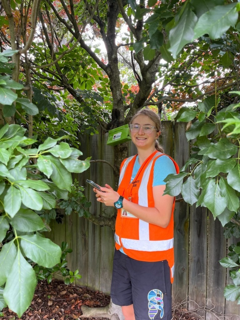
This has proved to be a good move with Jordyn, who finished the NZ Diploma in Environmental Management (Level 6) last year, currently doing conservation surveying and monitoring work. She is working for SPS Biota| Biosecurity & Environmental Services, collecting data about the Brown Marmorated Stink Bug and Spongy Moth – both serious pests and risks to NZ fruit and vegetable industries. This project started in October and runs until April 2025.

Jordyn, 20, attended Iona College in Havelock North and won a Year 13 scholarship in 2022 to study at EIT. A Year 13 Scholarship, which is offered annually by EIT, covers one year of tuition fees. The Scholarship supports school leavers across the Hawke’s Bay and Tairāwhiti regions to study any one of EIT’s degrees or selected level 5 diploma programmes that lead into a degree by providing one year FREE study.

Jordyn Campbell completed the NZ Diploma in Environmental Management (Level 6) at EIT last year and is looking forward to completing her Bachelor of Applied Science (Biodiversity Management).

Jordyn entered the Environmental Management programme in 2023, completing her level 5 NZ Diploma in Environmental Management, and has loved every moment.

“I live on an orchard, too, so I decided to study more about the environment around me, because I’ve been growing up in a rural area.”
She says choosing EIT to study at was an easy decision, especially when she won the Year 13 scholarship.

“It was close to home and easier to study there, especially since I liked the sound of the programme. The scholarship also helped me make the decision.”

Jordyn says that her new job is working on behalf of the Ministry for Primary Industries and involves searching for evasive species of Spongy Moths and Brown Marmorated Stink Bugs in Napier, Hastings and Havelock North.

“We have an app called Field Maps and it has all the locations on it, which are indicated by dots on the map. You complete forms depending on if you get a sample or you’re just doing a trap clearance, and then it will change the colour of the dots on the map. There are 63 traps for the Spongy Moth and six traps for the Brown Marmorated Stink Bugs across Hawke’s Bay.”

This year Jordyn will be completing her final year of study to achieve the Bachelor of Applied Science (Biodiversity Management). As for the future, Jordyn is leaning towards working in biosecurity, but she does not rule out studying further.

She says that wherever she winds up, she will not forget what she has learned from EIT. She has no hesitation in recommending the institute to others.

“I like EIT because you get to know everyone on a very personal level, including the lecturers. You are not just a number to them, you’re an actual person and you get one-on-one help from them.”

Environmental Management Lecturer Dr Glen Robertshaw says: “I think this is a fantastic opportunity for Jordyn, who I know really enjoyed our level 6 Biosecurity course”.

“It is also a real validation of the value of our programme and demonstrates that what we are teaching can lead to employment locally. It’s great to think that one of our students is helping to protect the local horticulture industry from invasive species that could potentially devastate it.”

SH15 expected to reopen shortly

Source: New Zealand Transport Agency

|

NZ Transport Agency Waka Kotahi (NZTA) advises State Highway 15 is expected to reopen between Maungatapere and Otaika around 2pm this afternoon.

The road has been closed since yesterday morning (Wednesday 29 January) to allow NZ Police to investigate following the unexplained death of a motorcyclist.

NZTA thanks everyone for their patience during the closure.

Tags

Native species compromised by trap vandals

Source: Department of Conservation

Date:  30 January 2025

In early January, high trapping lines between Dart Valley and the west Matukituki Valley were checked by Matukituki Charitable Trust volunteers and Southern Lakes Sanctuary staff, who found the entrances to all 45 traps blocked off by strategically placed rocks.

Staff have since found all the traps from Shelter Rock hut to Dart hut and down the Rees valley have also been triggered or had rocks placed in front of their doors.

“This means someone has made the effort to disarm more than 150 remote traps in total across two locations,” says DOC Operations manager Whakatipu David Butt.

“At this time of the year this line of traps catches numerous predators, including stoats.

“This is a critical time to have protection for native species through trapping. The people who have done this to the traps will be responsible for an increase in the death of many individuals from our taonga species.”  

An introduced species, stoats are the number one killer of many of New Zealand’s endangered native species.

“We have a team of hardworking DOC rangers, Southern Lakes Sanctuary staff and volunteers who put in a lot of hard graft to ensure our trapping network is effective,” says David.

“It is very concerning someone – or potentially several people – covered challenging terrain and clambered through bush to find these traps and block them off so predators cannot enter. It means we will see an increase in predators.”

DOC’s Takahē Recovery Group is working to establish a new population of the birds on and around Mt Aspiring. There are concerns those birds will be at risk if traps in the area are found to be compromised as well.  

Trapping is considered a humane method of removing introduced predators from our National Parks to protect native birds, lizards, and invertebrates.

Nature in New Zealand is unique and special. Most of it is only found here, and evolved without the introduced predators DOC and other conservation organisations strive to control. Once our species are gone from here, they’re gone from everywhere.

If anyone has any information about the traps that have been targeted, we urge them to call call 0800 DOC HOT (0800 362 468).

Contact

For media enquiries contact:

Email: media@doc.govt.nz

More extreme weather predicted for subants

Source: Department of Conservation

Date:  30 January 2025

“Up until now, we’ve lacked information on the climate change impact on subantarctic islands,” Drew Bingham, DOC Principal Science Advisor says.

“We knew we had to take a deeper look and identify actions needed to ensure the survival of the taonga species that depend on the islands for their survival.”

The study focuses on 11,300-ha Campbell Island, 740km south of Dunedin. Its terrain is steep, rugged and covered in extensive peat. The highest point is 569m.

“Meteorological observations were made over 83 years, which was an excellent base to start with, and gave us confidence in identifying past trends,” Drew says.

“The pattern we’ve observed is a general increase across all climate indicators related to warmer conditions. This is expected to continue into the future.

“Increases in temperatures, rainfall and wind are projected for Campbell Island. Winter rainfall is expected to be particularly heavy, with a warmer atmosphere storing more water vapour and increasing the severity and intensity of downpours.”

Drew says these climate projections have implications for conservation management on Campbell and other subantarctic islands.

“Extensive rainfall events and slips will potentially have the biggest impact on nesting birds. We’d also like to find out more about how sea level rise and storm surges will affect sea lions.

“Increasing the resilience of the subantarctic islands and keeping them pest-free becomes even more important in the face of climate change, especially given the wealth of biodiversity on many of the islands.

“The project to remove pests from Campbell island’s neighbour, Maukahuka/Auckland Island, is a great example, and will boost the climate change resilience of Auckland Island and by extension, the surrounding Southern Ocean.”

Data from the study shows the following trends and records for Campbell Island’s climate:

  • An increase in the average daily temperature over the past 83 years.
  • A decrease in the number of cold days over the past 83 years.
  • An increase in annual rainfall since 1970 (an additional annual rainfall of 79mm per decade).
  • The three warmest years and four wettest years on record were after 2011.

Drew says further research is still needed to assess the impact of the projected weather on Campbell Island’s species in more detail.

“This climate report is a good start as we look at ways to help our taonga species on the subantarctic islands adapt to climate change.”

Visit DOC’s website to download the report on the study.

The climate and weather of Campbell Island/Motu Ihupuku: historic observations and projected changes (PDF, 3,100K)

Background information

Campbell Island is part of New Zealand’s subantarctic World Heritage Site. It is the most southerly of the five New Zealand subantarctic groups.

Campbell Island is home to six species of albatross, including black-browed, grey-headed, light-mantled sooty and a small population of Gibson’s wandering albatross. Several critically endangered birds including the Campbell Island teal and Campbell Island snipe are found nowhere else. It has around 128 native vascular plants, which include several endemic herbs and grasses.

The island’s rat-free status was confirmed in 2006, following rat eradications in the early 2000s.

The Maukahuka project aims to eradicate feral pigs, feral cats and mice from Auckland Island so the island’s animals and plants can thrive. Visit DOC’s website for more information: Restoring Auckland Island – the Maukahuka project.

Contact

For media enquiries contact:

Email: media@doc.govt.nz

100s of NZ species highly vulnerable to climate change

Source: Department of Conservation

Date:  30 January 2025

The assessment looked at 1145 species of birds, bats, lizards, and frogs, as well as land-based invertebrates and plants, to identify the most vulnerable which can then be prioritised for conservation action to help protect them from climate change impacts.

Of the species assessed, 351 or 31% were classified as highly vulnerable to climate change by the mid-21st century, rising to 746 (65%) by late century.

Anni Brumby, DOC Senior Science Advisor and the report’s lead author, New Zealand is a hotspot for seabirds and known as the world’s seabird capital, which makes the changing climate a global survival issue.

“Seabirds travel internationally, but many depend on New Zealand’s territory for their breeding grounds. When we looked at climate change pressures such as projected sea level rise and warmer temperatures, fifty per cent of seabirds were assessed as highly vulnerable to climate change by mid-century.

“Snares penguin only breeds on one island and may have nowhere to go if climate conditions change drastically.

“Tara iti/fairy tern – New Zealand’s rarest bird – was found to be particularly vulnerable to climate change, as projected higher spring tides and increased storm surges could impact their Northland beach breeding ground and warmer temperatures could put additional stress on adults, chicks and eggs.”

All five New Zealand bat species were assessed as vulnerable by the late 21st century. Bats are already under pressure from predators, habitat loss, and human disturbance, which will only get more extreme as climate change progresses.

Many native plants identified as highly vulnerable in the assessment are already critically endangered and confined to rare ecosystems. Most South Island limestone dependent plants were assessed as highly vulnerable, such as the Castle Hill buttercup.

Pīngao, a taonga coastal plant species, is highly vulnerable to projected increases in coastal flooding and sea surges.

Reptiles and frogs already have small, highly fragmented populations. Climate change is predicted to increase the impact of current pressures, including habitat loss and introduced predators. The most vulnerable lizards include both alpine and coastal species.

Alpine invertebrates, including Paparoa tunnelling wētā, were also found to be vulnerable, as they may get increasingly squeezed out of their habitats with nowhere to go as the climate warms.

Anni says the large number of species assessed as highly vulnerable reflects the specialised habitats and threatened status of many native species due to small population sizes, limited distributions, and low reproductive rates.

“DOC’s ongoing work programme is focused on prioritising species and habitats where we can make the most difference. We know that when pressures are managed through tools such as invasive pest eradication, nature is restored and in turn, species and habitats become more resilient in the face of pressures including climate change.

“We also need innovative solutions such as establishing ‘insurance’ populations of rare species that could become extinct in a single extreme weather event and implementing nature-based solutions to help control climate-related erosion, for example.

“This information isn’t only useful for DOC – we also expect that other agencies, environmental NGOs, iwi, and communities will find this valuable data helpful to take action for nature,” Anni says.

DOC will continue its climate change adaptation research with risk assessments underway, focusing on highly vulnerable species to help identify any immediate action needed to prevent irreversible losses.

View the report

Trait-based climate change vulnerability assessments of terrestrial taxa in Aotearoa New Zealand

Contact

For media enquiries contact:

Email: media@doc.govt.nz

SH15 to remain closed overnight

Source: New Zealand Transport Agency

|

NZ Transport Agency Waka Kotahi (NZTA) advises State Highway 15 between Maungatapere and Otaika will remain closed overnight as NZ Police investigations into the unexplained death of a motorcyclist continue.

Detours remain in place via State Highway 14 and State Highway 1 for those traveling between Maungatapere and Otaika. Those traveling from Otaika to Maungatapere should take the same route, in reverse.

Motorists are asked to drive with care along the detour route, with increased traffic volumes and students having returned to schools in the area this week.

Locals who need to access their properties along the stretch of State Highway 15 between Maungatapere and Otaika should approach uniformed staff at the cordon.

The road is expected to remain closed into tomorrow afternoon and people are encouraged to visit the Journey Planner website (journeys.nzta.govt.nz(external link)) for up to date information on the closure and detour route before they travel.

NZ Transport Agency Waka Kotahi thanks everyone for their patience.

Tags

Saving threatened seabird from rising sea levels

Source: Department of Conservation

Date:  29 January 2025

Johannes Fischer, Department of Conservation Senior Science Advisor, says climate change impacts have the potential to wipe out the Whenua Hou diving petrel – a small seabird with cobalt blue feet that’s “like a flying penguin”.

“Their entire population breeds in the fragile sand dunes of Whenua Hou/Codfish Island, up to 20 m from the high tide line. Rising seas levels and increasingly frequent storms will eventually destroy their habitat on Whenua Hou. Over the last 10 years, 20% of the dune front has already gone,” Johannes says.

On 31 December 2024, 15 Whenua Hou diving petrel chicks were transferred from Whenua Hou to their new home. This is the first of five transfers over the next five years to move a total of 75 chicks – the number considered sufficient to build a new colony without causing any long-term impact to the Whenua Hou colony.

“Before humans arrived in New Zealand, Whenua Hou diving petrels bred all over the southern South Island and there were millions on Stewart Island/Rakiura. But until the recent transfer, they had reduced to a single population on Whenua Hou of just 210 individuals,” Johannes says.

Two years ago, mana whenua, DOC, fishers, the fishing industry, and Environment Southland developed an action plan to restore the petrels, which advised a second population at a new site was needed.

The group worked through a range of possible sites and identified an undisclosed, predator-free location within Whenua Hou diving petrel’s historic range as the best possible option.

All work is done in partnership with the Whenua Hou Committee (the advisory committee to the Minister of Conservation on the management of Whenua Hou), Ōraka Aparima Rūnaka, and Ngāi Tahu whānui.

Johannes says timing was crucial and the transfer had to take place roughly a week before the chicks fledged, before their homing instinct for Whenua Hou was developed.

“We hand-reared the chicks at their new home, and the last chicks fledged on 12 January 2025. Next season, we will translocate another 15 birds.”

“We expect the first group of translocated chicks to return to their new home as adults in October 2026. We’ll keep an eye out in anticipation.”

Contact

For media enquiries contact:

Email: media@doc.govt.nz

SH15 closed between Maungatapere and Otaika

Source: New Zealand Transport Agency

|

State Highway 15 is closed between Maungatapere and Otaika due to a serious incident.

There is a detour in place via State Highway 14 and State Highway 1 for those traveling between Maungatapere and Otaika. Those traveling from Otaika to Maungatapere should take the same route, in reverse.

The road is expected to remain closed for most of the day and people are encouraged to visit the Journey Planner website (journeys.nzta.govt.nz(external link)) for up to date information on the closure and detour route before they travel.

NZ Transport Agency Waka Kotahi thanks everyone for their patience.

Tags

Update: Serious crash closes State Highway 59 to southbound traffic near Porirua (one SB lane now OPEN)

Source: New Zealand Transport Agency


10 pm:

One southbound lane on State Highway 59 has been reopened to traffic following the crash earlier this evening.

The highway was closed to southbound traffic for approximately three and a half hours.

NZTA/Waka Kotahi and the Wellington Transport Alliance thank drivers for their patience and understanding this evening while the crash scene was investigated and cleared.

Drivers are asked to take care driving through the area until both southbound lanes have reopened


6:50 pm:

State Highway 59 is currently closed to southbound traffic from Mungavin Interchange to State Highway 1.

It follows a serious crash on the highway which occurred shortly before six o’clock this evening.

Southbound traffic heading to Wellington on State Highway 59 should avoid the area and use an alternative route.

The highway’s northbound lanes remain open.

Emergency services and contractors are attending the incident, and the southbound lanes are expected to remain closed until a Police Serious Crash Unit investigation is completed and the crash site is cleared.

Drivers are encouraged to check the highway’s status before they travel. Updates can be found on the NZTA/Waka Kotahi website.

Cambridge Road lane closure to be lifted 4 days ahead of schedule 

Source: New Zealand Transport Agency

|

Sheet piling works for the Tauriko Enabling Works project are ahead of schedule at the SH29/Cambridge Road intersection, which means the lane closure will be lifted overnight on Wednesday 29 January.

Traffic will be able to turn off SH29 into Cambridge Road again from Thursday 30 January. The remaining sheet piling and retailing wall works will start taking place behind the barrier and both lanes will be open for traffic.  

Works to improve safety at the SH29/Cambridge Road intersection have started off well, despite this area being challenging and narrow to work in, says Darryl Coalter, NZ Transport Agency Waka Kotahi (NZTA) Regional Manager, Infrastructure Delivery Waikato/Bay of Plenty (Acting). 

“Everything aligned. Great weather, good ground conditions, no machinery breakdowns and the opportunity for the crew to work extended hours, enabled this tricky stage of the job to be completed 4 days ahead of schedule,” says Mr Coalter. 

“Scheduling this work in January while schools are out and traffic volumes are lower helped minimise overall disruption to the travelling public. We’d like to thank everyone for their patience while this work was completed, especially residents, businesses and project neighbours.” 

Tauranga City Council Bethlehem Ward Councillor Kevin Schuler says seeing work associated with the lane closure completed ahead of schedule is a fantastic result. 

“This is a great start to works at the SH29 and Cambridge Road intersection, and an excellent outcome for businesses and for local residents we know use this route often.” 

 With the temporary sheet piles almost fully in place on this section of Cambridge Road, work can commence on the permanent retaining wall soon, says Mr Coalter.  

“Building a retaining wall in this location is complex due to the surrounding geography, traffic volumes on Cambridge Road and constructing a 210m-long concrete wall, with a steep gully on one side.  This is further complicated by multiple underground services that also need to be installed including power, water and fibre.  

“The retaining wall is a key step allowing us to widen the road, accommodating increased traffic and a shared path, and is scheduled for completion in late 2025. Once the retaining wall is completed, there will be a lane shift on Cambridge Road allowing intersection and drainage works to begin on the other side of Cambridge Road. 

“The upgrade of the SH29/Cambridge Road intersection is a key part of the Tauriko Enabling Works project.  It will be a much safer and more efficient intersection, including a new connection to Whiore Avenue for buses and people walking and cycling wanting to access Tauriko Business Estate.”